A Bike Trip to Death Valley
Sunday, 18 June 2006
Thursday 15 June. Wawona to Groveland

After a substantial buffet breakfast at the Hotels old style dining room we set off on our 3rd climb in 4 days of the 6000ft Wawona pass. We learned that traffic was heavier than usual on this road due to the closure of the main route into Yosemite, Highway 140.

We had a drama on the way down when one of the bolts securing Peters rack to the frame broke and the rack and panniers tilted backward onto the tyre. Peter managed to stop in time and the problem was fixed with the ever useful Zip Ties

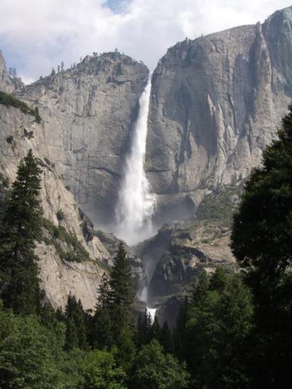
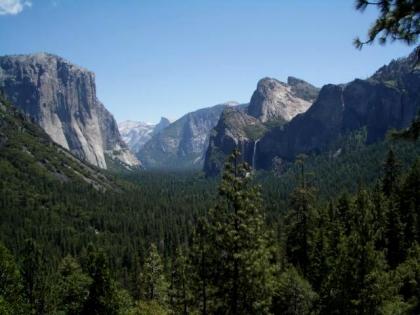
The scenery was very different to the first time we climbed the pass at night. We exited the Wawona tunnel to a great view of the Valley and the Bridalveil Falls set against unbroken clear blue skies.

The view was only spoiled by a coachload of Chinese Tourists. Martin was crouched down taking a picture when one of them came and sat on his back to take a picture!!

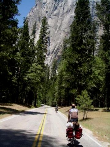
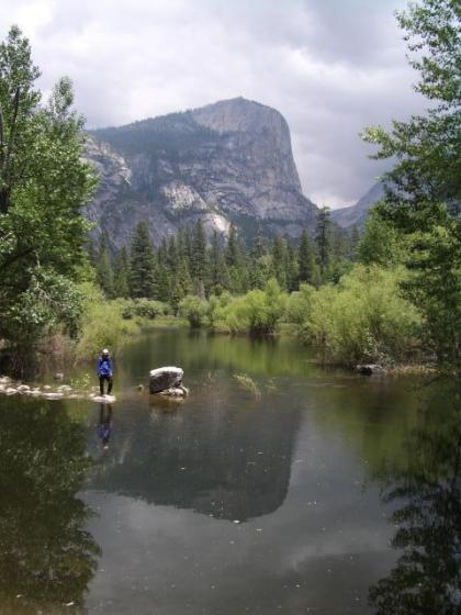
We continued on down to the valley and stopped for lunch at the meadows near the base of the 3000ft shear rock face of El Capitain.

A support man for some mountaineers came and spoke to us and was very impressed by our exploits. He impressed us even more by pointing out 4 mountaineers, tiny specks on the face of the giant El Capitain. He also told us that mountaineers took between 4 days and a week to climb the Rock Face.

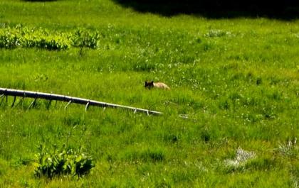
We continued to ride out of the Valley on Highway 120 West. We had great views but with the penalty of a hard climb to 6320ft. As we rode up we saw a lot of Park Ranger vehicles pass us. Near the top we saw the reason, a "Bear Jam" of traffic. In a meadow near the road was a female Brown Bear. The animal was crouched down in long grass and difficult to make out clearly.

The descent proved almost as hard as the climb with frequent descents followed by long climbs.By about 7 we reached the town of Groveland. We were due to go on another 25 miles but rather than have another night ride we cancelled the original booking and booked into a basic but detached Motel Cabin. Goveland was a small mountain town with a Saloon and a few Hotels.

67.6 miles for the day. 6036ft of climbing and 7139ft of descending.

Edwin


remote Posted by Edwin at 3:36 PM BST
Thursday 15 June. Riding towards El Capitain


remote Posted by Edwin at 3:28 PM BST
Thursday 15 June. Bear in the long grass


remote Posted by Edwin at 3:23 PM BST
Wednesday 14 June. Wawona and Mariposa Grove ride.

Today was a rest day in terms of not moving on as we were staying 2 nights at Wawona. The day dawned with bright blue skies. We decided to go up to the nearby Mariposa Grove of Giant Sequoia Trees. Although there was a shuttle bus up there we decided it would be a good idea to ride our bikes up the 1600ft climb to the Grove.

From the top we took a walk up the path among the great trees. The oldest was called the Grizzly Giant and was 2700 years old. Another nearby one had a hole cut through the trunk over 100 years ago for stagecoaches to drive through.

After a fast descent we spent the afternoon relaxing on the porch of the Hotel.

14 miles for the day with 1660ft of climb.

Edwin


remote Posted by Edwin at 2:02 PM BST
Wednesday 14 June. Mariposa Grove Giant Sequioa


remote Posted by Edwin at 1:54 PM BST
Wednesday 14 June. Mariposa Grove Ride. Peter and Martin ridng back to the grand Wawona Hotel


remote Posted by Edwin at 1:51 PM BST
Saturday, 17 June 2006
Tuesday 13 June. Yosemite Valley to Wawona.

Today we had to transfer to the southern end of Yosemite Park to Wawona. We would have preferred to stay in the main Valley Lodge but this had been booked solid for today and tomorrow for 12 months.

We had a short 30 miles but hilly ride to do so decided to spend the morning exploring parts of the Valley. After breakfast we took a short walk to the nearby Yosemite falls thundering 1000s of feet down the cliff.

After checking out of the Lodge we rode the bikes up bike paths for 3 miles to Mirror Lake where Half Dome is reflected in the lake. Half Dome is an enormous rock formation cut cleanly in two by the great glaciers which carved out the Valley.

From the bike path we viewed 4 climbers on a 2000ft high vertical rock face visible as tiny dots above us.

After lunch back at the lodge we headed back along the Valley to climb back up the Wawona road we had descended in the dark the previous night. After a sunny morning there were a couple of short showers in the afternoon and we got the chance to try out the Gore-Tex Coats we had been carrying around unused for 12 days.

After a long 10 mile climb to 6000ft we had a fast descent on the sweeping bends riding often only a little slower than the traffic.

The sun was out again as we arrived at the Wawona Hotel, a European style elegant hotel with verandas dating from the late 19th century.

34 miles for the day and 2522ft of climbing.

Edwin


remote Posted by Edwin at 5:08 AM BST
Tuesday 13 June. Yosemite Falls from near the Lodge


remote Posted by Edwin at 4:57 AM BST
Tuesday 13 June. Yosemite Valley. Mirror Lake.


remote Posted by Edwin at 4:53 AM BST
Friday, 16 June 2006
Monday 12 June. Reedley to Yosemite. A Marathon bike ride.

This was the last day of the 5 day diversion due to the Tioga Pass closure. We had to reach Yosemite Valley today to stay at the expensive Yosemite Lodge which had been booked and paid for 9 months ago. A couple of obstacles lay in the way, 115 miles plus the Sierra Nevada mountains!

After a 5.30 am breakfast at the local diner the first 25 miles was on pan flat backroads still in the valley. We bypassed Fresno on Academy road which had a wide bike path. A couple of problems here. First I picked up a giant sized fencing staple which led to a quick rear wheel puncture as we soon discovered the inner tube had been part stapled to the inside of the tyre. A few miles down the road my front wheel deflated, this time due to a drawing pin.

We continued north riding into the foothills of the Sierras on Highway 168.This was quite busy but we turned off it after 10 miles on backroads via Auberry at 2600ft but then a sharp 1200ft descent into a valley and then back up again to North Fork where we stopped for lunch in a Saloon. Then up and down alongside Bass Lake to Yosemite Junction where we stopped for an early 5.00pm dinner. We knew that with 45 miles to go we would arrive too late for a meal at Yosemite.

There then followed a very long climb to 5000ft and the entrance Station to Yosemite National Park. Then it was down to Wawona and as the sun was setting we started a 12 mile climb of 2000ft to 6000ft which took us 2 1/2 hours by which time it was well dark.

The descent was interesting!. There were a few mutterings from the ranks about nightmares. We had to descend slowly to see with our front lights the white line at the edge of the road and the occasional pothole. The cold night-time mountain air meant we shivered our way down in stark contrast to the heat of Death Valley earlier in the trip. We had to stop occasionally to point the front lights up at road signs to be sure we were on the right route. We had heard about Black Bears around at night in Yosemite tearing cars apart to get at food. We wondered about the Power Bars in our Panniers and decided to abandon our bikes if the occasion arose

A mile long lit tunnel into Yosemite valley gave us little warmth and a faster descent as we could see better where we were going. As we descended into Yosemite Valley we could see even by starlight the great cliffs towering 1000s of feet above us and the great waterfalls roaring into the valley fed by snowmelt from the high Sierras.

We eventually found Yosemite lodge by the Falls and rolled up outside the grand entrance to reception at 11.40pm. The receptionist had various forms to fill in relating to our motor vehicle and didn't immediately grasp the concept that we had bicycled into the park. However she then got us checked in quickly and we collapsed into warm beds in short order.

I said earlier in the blog that the ride to Ridgcrest was my hardest in many years. This one beat it in distance and amount of climbing. For those not into bike riding I have a handlebar mounted bike Speedo known as a bike computer which also includes an altimeter and gives an accurate figure for the total amount of climbing in a day. Today's total was 10,006ft for the day ie 1/3 the height of Everest and my highest total everfor a day. Distance was 115 miles and time riding the bike was 12 hours 48 minutes. It was 17 hours from start of the days ride to the end.

The picture below was taken a few days later wnen we climbed the same hill into Yosemite in the light to show the view we would have had if it was not pitch black.

Edwin


remote Posted by Edwin at 6:19 PM BST
Monday 12 June. Yosemite Valley. View we would have had if it was not dark.


remote Posted by Edwin at 5:58 PM BST
Sunday 11 June. Porterville to Reedley

Today's ride was due north along the San Joaquin valley to the west of the Sierras. The previous evening we had found a diner near the hotel in Porterville called the Black Bear Diner. Their motto was" eat like a bear" and their portions were enormous even by American standards. My breakfast was a great bowl of porridge followed by a stack of 3 giant sized thick American pancakes piled with strawberries. I got through three quarters of this and then for first time on one of these trips even I was defeated. Definitely a "Senior moment"

The San Joaquin Valley is part of the central California plains over a 100 miles wide. Our route north was "flat as a pancake" and the roads were dead straight laid out in a grid. To head a little NW as we did it was necessary to take a northern road then a road going west and then a road going north.

We had a good tail wind for a change and rode at a fast pace along roads lined with Orange trees, vineyards or Olive trees. On the eastern horizon the snow-capped peaks of the high Sierras were visible. We rode through Strathblain and then stopped for elevenses at Exeter

We were in a largely Spanish American area and stopped for lunch at a Mexican restaurant.

Most American maps are large scale and light on detail. I had located however from Stanford's in London a California Atlas and brought with me relevant pages. This was invaluable for this area with its numerous roads as there were few route signs, only the name or often the number of the road which was shown on the Atlas. This enabled me to find routes on quieter roads.

We were still on the diverted route due to the closure of the Tioga pass. I wanted to stop for the night west of Fresno to follow a route north towards Yosemite but bypassing Fresno which is a big City. I had not been able to find any motels on the Internet in the area so we stopped at the first decent sized town which was Reedley about 20 miles SE of Fresno and asked in a store for directions to a motel.

One notable thing about American towns such as this is that they are spread out in a grid pattern covering probably 4 times the area of a European town of the same population and with a much less defined centre. We cycled for miles coming into town without seeing anybody walking on the pavement (sidewalk) Everything is laid out for travel by car.

61 miles for the day and 196ft of climbing. My bike Computer/Altimeter was more sensitive than I was as I didn't notice any climbing all day.

Edwin


remote Posted by Edwin at 5:51 PM BST
Sunday 11 June. Giant sized start for the day


remote Posted by Edwin at 5:41 PM BST
Monday, 12 June 2006
Saturday 10 June. Lake Isabella to Porterville.

Today we left Lake Isabella on a usual day of clear blue skies and rising temperatures.

After a few miles we reached the start of the locally notorious 6000ft climb over the Sierras on route 155 via Alta Sierra. We soon found out why as the road reared up with gradients on average of 15% and reaching 21%. This went on for 8 miles. As the heat rose sweat poured into our eyes and we struggled with our lowest gears. For those in Sussex think of riding up Duncton Hill and steeper for 8 miles. For those in Dorset think of riding up Eggerdon for 8 miles.

After a few false summits we reached the top with much relief. Traffic on the climb was light and hardly any on the descent. The scenery could not be more different from yesterday with the climb being thickly wooded and even some Redwoods at the top. The descent was one sweeping curve merging into another and I kept pace with a motorbike for a few miles.

The thickly wooded slopes were part of the Sequoia National Forest. Further down this gave way to more open ranchland. We stopped at Glenwood at the Crazy Horse Saloon for lunch. The local cowboys and girls were well impressed at our cycling up their steep pass. Martin had bought a Cowboy hat at Furnace Creek and decided to blend in better by wearing it in the Saloon.

We continued on some quiet backroads descending through the foothills. Martin and Peter spotted a Golden Eagle swooping overhead.

Further down we stopped at the Fountain Springs Saloon for cold drinks as temperatures reached 94F.

Further on we came down to the central California plains of the San Joaquin Valley with orange and lemon groves lining the road. We stopped at a Motel 6 in Porterville overnight.

71.5 miles for the day with 5121ft of climbing and 7043ft of descending as our starting height at Lake Isabella was 2500ft.

Edwin


remote Posted by Edwin at 5:13 AM BST
Saturday 10 June. Lake Isabella from near the Dam


remote Posted by Edwin at 5:07 AM BST
Updated: Friday, 23 June 2006 7:49 AM BST

Newer | Latest | Older

You are not logged in. Log in
Entries by Topic
All topics  «