A Bike Trip to Death Valley
Monday, 12 June 2006
Saturday 10 June. Lake Isabella to Porterville.

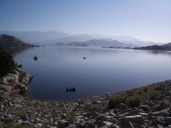
Today we left Lake Isabella on a usual day of clear blue skies and rising temperatures.

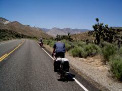
After a few miles we reached the start of the locally notorious 6000ft climb over the Sierras on route 155 via Alta Sierra. We soon found out why as the road reared up with gradients on average of 15% and reaching 21%. This went on for 8 miles. As the heat rose sweat poured into our eyes and we struggled with our lowest gears. For those in Sussex think of riding up Duncton Hill and steeper for 8 miles. For those in Dorset think of riding up Eggerdon for 8 miles.

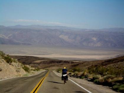
After a few false summits we reached the top with much relief. Traffic on the climb was light and hardly any on the descent. The scenery could not be more different from yesterday with the climb being thickly wooded and even some Redwoods at the top. The descent was one sweeping curve merging into another and I kept pace with a motorbike for a few miles.

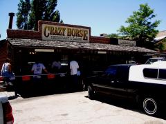
The thickly wooded slopes were part of the Sequoia National Forest. Further down this gave way to more open ranchland. We stopped at Glenwood at the Crazy Horse Saloon for lunch. The local cowboys and girls were well impressed at our cycling up their steep pass. Martin had bought a Cowboy hat at Furnace Creek and decided to blend in better by wearing it in the Saloon.

We continued on some quiet backroads descending through the foothills. Martin and Peter spotted a Golden Eagle swooping overhead.

Further down we stopped at the Fountain Springs Saloon for cold drinks as temperatures reached 94F.

Further on we came down to the central California plains of the San Joaquin Valley with orange and lemon groves lining the road. We stopped at a Motel 6 in Porterville overnight.

71.5 miles for the day with 5121ft of climbing and 7043ft of descending as our starting height at Lake Isabella was 2500ft.

Edwin


remote Posted by Edwin at 5:13 AM BST
Saturday 10 June. Lake Isabella from near the Dam


remote Posted by Edwin at 5:07 AM BST
Updated: Friday, 23 June 2006 7:49 AM BST
Saturday 10 June. Lunch stop at the Crazy Horse Saloon


remote Posted by Edwin at 5:05 AM BST
Updated: Friday, 23 June 2006 7:51 AM BST
Friday 9 June. Ridgecrest to Lake Isabella

Our diverted route could have taken us south to Bakersfield and then north from there but that would have been longer and with much more traffic. This route on Highway 178 today and 155 tomorrow is much quieter and takes us over the Sierras via a 5000ft pass today and a 6000ft pass tomorrow.

With a shorter mileage and having left the extreme heat of Death Valley we decided to get up at a near normal time and took in the Best Western Buffet breakfast.

We headed due west from Ridgecrest via Inyokern and then started climbing to Highway 14. This was very busy for a few miles and we were glad to leave it for the quieter route 178 up to Walkers Pass.

We were still on the eastern slopes of the Sierras with a desert landscape. As we climbed we saw more and more Joshua Trees, a type of Cactus.

As we reached the pass at 5173ft we saw our first real trees in a week and stopped in some shade for lunch. The descent was winding and into the usual headwind. Temperatures rose to 96F and we were glad to see a cafe on the way down for some cold drinks. The landscape was a mixture of barren desert hills and a lush valley floor and even some cows.

Lake Isabella is a beautiful lake surrounded by mountains with the town just below the Dam.

63 miles for the day with 3362ft of climbing.

Edwin


remote Posted by Edwin at 3:04 AM BST
Friday 9 June. Cycling up Walkers Pass among Joshua Trees


remote Posted by Edwin at 2:48 AM BST
Updated: Friday, 23 June 2006 7:53 AM BST
Thursday 8 June. Stovepipe Wells to Ridgecrest. Escape from the Valley of Death

Today we started a major diversion from the originally planned route. Over the next 5 days we should have had rides with fairly reasonable mileages taking us to the valley to the west of the Sierra Nevada and then over the Sierras to Yosemite on the 10,000 ft Tioga Pass. This is normally open late May or early June. However this year they had twice the normal amount of snow and it did not look likely that it would open until late June.

Our diversion took us a long way south. Today's ride was 97 miles instead of the planned 35 miles and 5 days of booked accommodation had to be cancelled but this was with enough notice to avoid any charge.

For today's marathon ride we had a climb out of Death Valley from sea level at Stovepipe Wells to the 4900 ft Towne Pass to start the day.

After an early night we were up at 2.00 am and on the road at 3.00 am. A somewhat surprised receptionist took our Keys.

The 18 mile climb was on a clear starlit night with the band of the milky way above us. We decided that on such a climb it was better not to be able to see how far it was to go or how steep it was. After the few lights of Stovepipe Wells disappeared from view there were no lights or sign of habitation visible anywhere.

We were on a numbered Highway, Route 190, the main route west and yet we saw not a single car for 3 1/2 hours until we were nearing the top of the pass. Earlier we saw the last of Death Valley behind us as the first light of Dawn broke. Temperatures during the climb were reasonable starting at 87f and coming down to 68 f just before dawn with greater height.

The descent was into the adjoining Paramint Valley with outstanding views in the early light of the desert ridges and mountain peaks and the salt flats of the desert floor.

At the bottom we did a left turn to head due south on the Paramint Valley Road for 40 mile of straight desert road. There was very little traffic and the peace was only broken by a jet fighter roaring low above us on training flights up and down the valley.

For 40 miles of the valley there was no habitation only salt flats and shrubs. We had lunch from supplies in
Our bags. As temperatures climbed to 106F under the searing blue skies we increasingly looked forward to a cold drink at the first town of Trona. We eventually arrived and at the first cafe ordered the XL cups of sprite. Then when delivered these turned out to be giant sized plastic cups of about 1 1/2 litres.

The last 25 miles to Ridgecrest was a bit of a nightmare with the road gradually uphill all the way and directly into a 20mph hot desert wind. The Best Western at Ridgecrest was a welcome sight when we arrived at 7.00pm. The hardest days ride for all of us for many years

97 miles for the day and 7532ft of climbing.

Edwin


remote Posted by Edwin at 1:45 AM BST
Thursday 8 June. Descending to Paramint Valey


remote Posted by Edwin at 1:39 AM BST
Thursday 8 June. Endless desert road in the Paramint Valley


remote Posted by Edwin at 1:35 AM BST
Friday, 9 June 2006
Wednesday 7 June.Furnace Creek to Stovepipe Wells.

Today was a short 24 mile ride to move on further north in Death Valley to Stovepipe Wells. A little later start than yesterday but we were checked out and on the road soon after 5.00am.

Overnight and early morning cloud kept temperatures high at 96F. The ride along the valley floor was assisted by a strong southerly tail wind.

We stopped enroute first at an area known as the Devils Cornfield, an area of tufted arrowweed grasses perched on mounds that make them look like Cornstocks. Next we stopped at the Sand Dunes an area of 15 square miles of sand dunes some as much as 100ft high.

We arrived at Stovepipe Well to checkin at 7.50 which is certainly a record on any tour I have been on. They had rooms ready to move into and we then went to the All you can eat Breakfast Buffet. The rest of the day was a real rest day spent lounging in the shade beside the pool with the occasional dip to cool off as temperatures climbed to 107F.

Miles for the day 24 with 544ft of climbing.

Edwin


remote Posted by Edwin at 5:51 AM BST
Tuesday 6 June. Furnace Creek Rest Day. Out and back ride to Dantes View.

This was nominally a rest day i.e. not a moving on day. However not many rest days are like this one which involved a 3.00am start for a 25 mile climb to a 5475ft viewpoint. We started at 190ft below sea level so we had 5665ft of climb.

At 3.00 am temperatures in the small Furnace Creek urban area were 96F coming down to 87 out of town. The lowest temperatures are just before sunrise. As we rode upward it was in utter quiet. The first vehicle we saw was one and a half hours later. We rode with the shining band of the Milky Way above us crystal clear in the desert air. Either side of us the dark silhouettes of rocky ridges and peaks rose above us.

Further up as the first glimmerings of dawn showed in the eastern sky Venus rose ahead of the Sun. We turned off the main road onto the dead-end Dantes View road. Part way up the sun cleared the ridges to the east. We continued with what seemed a never ending climb. The last 1/4 mile produced a sting in the tail as the road reared up with gradients of 15 to 18%.

The viewpoint made it all worthwhile with the most spectacular view I have seen. Below us was the whole of Death Valley 140 miles long and 50 miles wide in places. On the valley floor salt flats shone white in the rising Sun. The jagged mountains of the Paramint range lined the Valley to the east with alluvial fans spreading from their base. Canyons and multi-coloured rocks were visible below. Beyond the Paramint range some of the 100 mile distant snow covered Peaks of the Sierra Nevada were visible.

We had arrived at 7.00am and had the utterly remote view to ourselves for an hour until the first Tourists arrived. We descended back to the valley floor in 1 hour 15 mins. We went to the National Park Visitor Centre a mile up the road from our base and then returned for our usual lunch buffet.

I washed some clothes which dried in about 20 minutes in the by now 115F desert heat.

50 miles for the day with 5665ft of climb.

Edwin


remote Posted by Edwin at 5:48 AM BST
Tuesday 6 June. Peter riding towards Dantes View soon after Dawn


remote Posted by Edwin at 5:39 AM BST
Tuesday 6 June. Death Valley from Dantes View 1


remote Posted by Edwin at 5:35 AM BST
Tuesday 6 June. Death Valley from Dantes View 2


remote Posted by Edwin at 5:32 AM BST
Monday 5 June. Furnace Creek rest day. Ride to Badwater. Riding in the shadow of the Valley of Death.

Today we did an out and back ride to Badwater basin, the lowest point in the western hemisphere at 282ft below sea level. After some snacks in the room we were on the road by 5.00am temperatures at this time were a relatively cool 86F. Shirts came off at a record early time.

The road was up and down on the valley floor next to the Black Mountains bounding the eastern side of the valley. Salt flats were on the valley floor and on the opposite side of the valley the stark ridges of the Paramint Mountains caught the first rays of the rising Sun. We rode in the shadow of the Black Mountains.

After 18 miles and approaching Badwater we were still in welcome shadow with the sheer walls of Coffin Peak directly above us.

At Badwater Basin which is a viewing point not a town we were the only people around apart from a road crew. We were able to walk onto the Salt flats which shined a brilliant white like snow when the sun reached them. High above us on the cliff was a sign marking Sea Level

On the way back Peter headed back direct while Martin and I took the Artists Drive loop road which winds for 8 miles among multi coloured rocks. The only problem with the route was that it started with a very steep 1000ft climb which even Martin and I found very hard in temperatures which at 8.30 pm had already climbed to 96F.

We returned to base at 10.45 with temperatures 105F. The rest of the day was spent eating, writing postcards, sleeping and more eating. After dinner we spotted 4 Coyotes on the Furnace Creek Golf course, presumably part of a small colony.

42 miles for the day and 2555ft of climb.

Edwin


remote Posted by Edwin at 4:57 AM BST
Monday 5 June. Early morning riding towards Badwater


remote Posted by Edwin at 4:52 AM BST
Updated: Friday, 23 June 2006 10:58 AM BST

Newer | Latest | Older

You are not logged in. Log in
Entries by Topic
All topics  «